


Voting Districts not defined, Ocean County, New Jersey
About
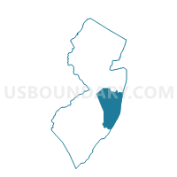
Outline

Summary
| Unique Area Identifier | 621294 |
| Name | Voting Districts not defined |
| County | Ocean County |
| State | New Jersey |
| Area (square miles) | 158.71 |
| Land Area (square miles) | 0.00 |
| Water Area (square miles) | 158.71 |
| % of Land Area | 0.00 |
| % of Water Area | 100.00 |
| Latitude of the Internal Point | 39.94453020 |
| Longtitude of the Internal Point | -74.05565570 |
Maps


Graphs
Select a template below for downloading or customizing gragh for Voting Districts not defined, Ocean County, New Jersey


Neighbors
Neighoring Voting District (by Name) Neighboring Voting District on the Map
- Barnegat Light borough voting district 1, Ocean County, NJ
- Bay Head borough voting district 1, Ocean County, NJ
- Beach Haven borough voting district 1, Ocean County, NJ
- Berkeley township Island Beach State Park, Ocean County, NJ
- Berkeley township ward 1 voting district 3, Ocean County, NJ
- Brick township voting district 26, Ocean County, NJ
- Dover township voting district 26, Ocean County, NJ
- Dover township voting district 8, Ocean County, NJ
- Galloway township voting district 8, Atlantic County, NJ
- Harvey Cedars borough voting district 1, Ocean County, NJ
- Lavallette borough voting district 2, Ocean County, NJ
- Little Egg Harbor township voting district 5, Ocean County, NJ
- Little Egg Harbor township voting district 6, Ocean County, NJ
- Long Beach township voting district 1, Ocean County, NJ
- Long Beach township voting district 2, Ocean County, NJ
- Long Beach township voting district 3, Ocean County, NJ
- Manasquan borough voting district 3, Monmouth County, NJ
- Mantoloking borough voting district 1, Ocean County, NJ
- Point Pleasant Beach borough voting district 3, Ocean County, NJ
- Point Pleasant Beach borough voting district 4, Ocean County, NJ
- Seaside Heights borough voting district 1, Ocean County, NJ
- Seaside Park borough voting district 1, Ocean County, NJ
- Seaside Park borough voting district 2, Ocean County, NJ
- Ship Bottom borough voting district 1, Ocean County, NJ
- Surf City borough voting district 1, Ocean County, NJ
- Voting Districts not defined, Atlantic County, NJ
- Voting Districts not defined, Monmouth County, NJ
Top 10 Neighboring County Subdivision (by Population) Neighboring County Subdivision on the Map
- Toms River township, Ocean County, NJ (91,239)
- Brick township, Ocean County, NJ (75,072)
- Berkeley township, Ocean County, NJ (41,255)
- Galloway township, Atlantic County, NJ (37,349)
- Little Egg Harbor township, Ocean County, NJ (20,065)
- Manasquan borough, Monmouth County, NJ (5,897)
- Point Pleasant Beach borough, Ocean County, NJ (4,665)
- Long Beach township, Ocean County, NJ (3,051)
- Seaside Heights borough, Ocean County, NJ (2,887)
- Lavallette borough, Ocean County, NJ (1,875)
Top 10 Neighboring Place (by Population) Neighboring Place on the Map
- Manasquan borough, NJ (5,897)
- Point Pleasant Beach borough, NJ (4,665)
- Seaside Heights borough, NJ (2,887)
- North Beach Haven CDP, NJ (2,235)
- Lavallette borough, NJ (1,875)
- Seaside Park borough, NJ (1,579)
- Dover Beaches North CDP, NJ (1,239)
- Dover Beaches South CDP, NJ (1,209)
- Surf City borough, NJ (1,205)
- Beach Haven borough, NJ (1,170)
Top 10 Neighboring Elementary School District (by Population) Neighboring Elementary School District on the Map
- Berkeley Township School District, NJ (41,255)
- Galloway Township School District, NJ (37,349)
- Little Egg Harbor Township School District, NJ (20,065)
- Long Beach Island School District, NJ (6,323)
- Seaside Heights Borough School District, NJ (2,887)
- Lavallette Borough School District, NJ (1,875)
- Seaside Park Borough School District, NJ (1,579)
- Beach Haven Borough School District, NJ (1,170)
- Bay Head Borough School District, NJ (968)
Top 10 Neighboring Secondary School District (by Population) Neighboring Secondary School District on the Map
- Greater Egg Harbor Regional School District, NJ (74,242)
- Central Regional School District, NJ (49,405)
- Southern Regional School District, NJ (34,028)
- Pinelands Regional School District, NJ (26,458)
Top 10 Neighboring Unified School District (by Population) Neighboring Unified School District on the Map
- Toms River Regional School District, NJ (108,095)
- Brick Township School District, NJ (75,072)
- Manasquan Borough School District, NJ (5,897)
- Point Pleasant Beach Borough School District, NJ (4,961)
- School District Not Defined (Water), NJ (0)
Top 10 Neighboring State Legislative District Lower Chamber (by Population) Neighboring State Legislative District Lower Chamber on the Map
- General Assembly District 9, NJ (236,923)
- General Assembly District 2, NJ (234,905)
- General Assembly District 10, NJ (208,227)
- State House Districts not defined, NJ (0)
Top 10 Neighboring State Legislative District Upper Chamber (by Population) Neighboring State Legislative District Upper Chamber on the Map
- State Senate District 9, NJ (236,923)
- State Senate District 2, NJ (234,905)
- State Senate District 10, NJ (208,227)
- State Senate Districts not defined, NJ (0)
Top 10 Neighboring 111th Congressional District (by Population) Neighboring 111th Congressional District on the Map
- Congressional District 4, NJ (724,596)
- Congressional District 2, NJ (692,205)
- Congressional District 3, NJ (680,341)
- Congressional District 6, NJ (668,806)
Top 10 Neighboring Census Tract (by Population) Neighboring Census Tract on the Map
- Census Tract 105.01, Atlantic County, NJ (7,299)
- Census Tract 7280, Ocean County, NJ (5,072)
- Census Tract 7101, Ocean County, NJ (4,665)
- Census Tract 8093.02, Monmouth County, NJ (2,671)
- Census Tract 7390, Ocean County, NJ (2,361)
- Census Tract 7380.01, Ocean County, NJ (2,235)
- Census Tract 7270.01, Ocean County, NJ (1,853)
- Census Tract 7381, Ocean County, NJ (1,526)
- Census Tract 7380.02, Ocean County, NJ (1,371)
- Census Tract 7120, Ocean County, NJ (1,264)
Top 10 Neighboring 5-Digit ZIP Code Tabulation Area (by Population) Neighboring 5-Digit ZIP Code Tabulation Area on the Map
- 08742, NJ (24,405)
- 08087, NJ (24,104)
- 08736, NJ (12,578)
- 08008, NJ (6,975)
- 08751, NJ (4,212)
- 08735, NJ (3,114)
- 08752, NJ (2,074)
- 08738, NJ (1,042)
- 08006, NJ (518)